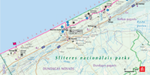
CARTOGRAPHY AND MAP MAKING

While using our own geographical data set or any available open geospatial data source, our highly skilled team creates maps for different purposes and needs. We are well experienced in operating with open geodata of Sweden, Norway and Finland as well as with other data sources. The creation of map starts with data acquisition, compilation and processing in common database which is followed by .mxd file creation which stores the symbols, layout and other customization. Then comes finetuning of the map, improvement of readability and visualization. Our experience in preparing and providing maps cover such areas as tourism, sport, property management, transport and aviation.

TOURISM INFORMATION SERVICES

Every place has its own character and uniqueness. Every traveler – no matter, a hiker, a cyclist or a rafter – has their own needs and desires and we are ready to find out the best way how to provide information to everyone. When we combine your idea and our experience, we get exhaustive and easy-to-use publications for tourists. A4 maps for city-walkers, tour guides for car drivers, brochures and folded maps for those who are looking for local experiences and super durable maps on Tyvek or Polyart for outdoor life enthusiasts. Full service guaranteed from idea to layout design, creation of maps, translation in several languages, proof-reading and printing. If needed – door to door delivery as well. What is new? A map machine service which is common in Finland!

PRINTING AND PRODUCtion SERVICES

During the years we have established a cooperation and wide network of reliable and trustworthy partners in Latvia, Lithuania, Poland, Germany and Italy. Printing houses are ready to fulfill printing on demand according to requested technology, paper (or other material) quality, print-run, post-processing (cutting, folding, stitching, laminating and more). This gives us an opportunity to find the most cost-efficient solution in terms of quality, delivery time and costs. Maps, wall-maps, cardboard tubes, scratch-off maps, puzzles and more – all in our service. We provide “one-stop shop” approach including planning, producing and delivery. Tour guides printed in Latvia, maps printed in Italy, plastic holders produced in Latvia, all packed in accurate sets and delivered to Sweden – yes, we can!

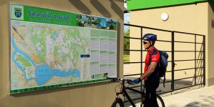
LARGE FORMAT MAPS AND INFORMATION BOARDS

Outdoor information board is often the first information source for the traveler who is visiting the location. Detailed maps are supplemented with descriptions and information about the location or tourism destination. Sizes and materials for boards varies a lot – from small ones devoted to a sightseeing object to boards with the size of several square meters with information about the whole region. Plastic or aluminum composite material, covered with anti-graffiti ensures long service life. Of course, large format maps might be useful not only outdoors, they can be attractive interior design elements as well.

OUR WORKS/CUSTOMER REFERENCES

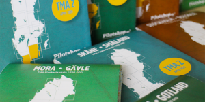
Maps for Baltic Coastal Hiking Guide

“We have had a good cooperation with Jana seta for a long time. One of the latest and most prominent works is the creation of Baltic Coastal Hiking Guide – around 1200 km long hiking route along the Baltic Sea coast between Riga and Tallinn, where Jana seta prepared 60 map sheets (1 cm = 1 km) for one day walks, as well as a route overview map. These thematic maps include information about interesting sights and services – accommodation, catering, shops, recreation places etc. Jana seta maps are modern and high-quality products, and are useful for both travelers and specialists in different fields.”

Juris Smaļinskis, Tourism and environmental expert, The Latvian Country Tourism Association “Lauku ceļotājs”

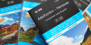
Kungsleden map & guides series

“When we started this project, my requirement was that the maps and guides should be available in bookstores before the start of the active tourism season. We started in January and in May the series of 5 map + guide sets were in our store. It was really intense, focused and purposeful job to all the team: cartographers, text editors, translators, graphic designers, producers and project managers on both sides. This project was a visualization of what can be called an outstanding teamwork.”

Pedro Pettersson, Publishing director maps, Norstedts Kartor

Aeronautical map products

“Jana seta maintain and produce our digital and physical aeronautical map products that are commercially available in our store. Our map products consist of the Swedish 1:250 000 VFR maps, encompassing the Swedish FIR, the Swedish VFR airfield guide Svenska Flygfält, encompassing the Swedish AIP airfields and digital versions of the two above products, made available through our apps. In our partnership Jana seta have shown great expertise and adaptability in their work with aeronautical data. Throughout our business cooperation we have experienced professional and timely results on all tasks allocated. We are happy with services provided!”

Martin Trankell, Project Lead, Map Products – Pilotshop.se

CONTACT US

JĀNIS BARBANS

Executive Manager,
Custom-Made Products Business Unit


Phone: +371 67317540, +371 29677248
E-mail: janis.barbans@kartes.lv

We are open for new ideas and customized solutions. Please contact us to get an offer for realization of your ideas!